A Digital Elevation Model (DEM) is a general representation of heights above or below a reference geoid (where the geoid is a mathematical shape of an orb, for instance Earth). A Digital Terrain Model (DTM) refers to the natural surface of the Earth, i.e. disregarding vegetation, buildings and other 3 dimensional (3D) human structures. A Digital Surface Model (DSM) instead includes all human 3D objects. Theoretically the conceptual definitions of DTM and DSM are more strict, with DEM being more widely defined. In reality the three concepts are mixed and note seldom used interchangeably. The Arctic DEM is defined as a DSM.
Overview
In this post you will add the ArcticDEM to your GeoImagine Framework. To be effective and cover the correct region, you have to start with defining a default region that fits the ArcticDEM. Then you have to link that default region to a project owned by your user (i.e. the system superuser). When you have created your own project and region you can import the ArcticDEM as an ancillary layer, and then tile it to the MODIS SIN grid (modis) system.
Arctic DEM
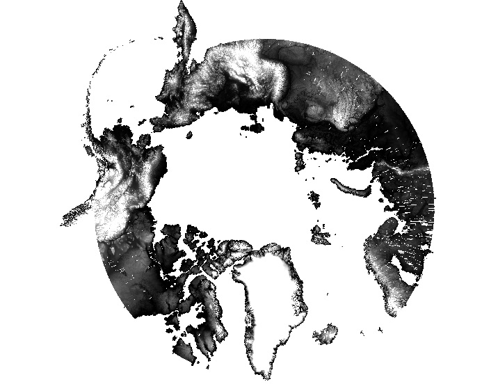
The Arctic DEM is an effort led by the United States National Geospatial-Intelligence Agency (NGA) and the National Science Foundation (NSF) to create a high resolution DEM of the Arctic land area. The DEM is created from optical stereo imagery, high-performance computing, and open source photogrammetry software. The DEM covers all land areas north of 60 degrees, all territory of Greenland, the State of Alaska in entirety, and the Kamchatka Peninsula of the Russian Federation.
Arctic Digital Elevation Model (DEM) in polar stereographic projection (orignal download format).
Create a default regions
The Arctic DEM does not really fit in any of the predefined default regions in Karttur’s GeoImagine Framework. To accommodate and work with the Arctic region, you can create some new default regions. In my version I created three new default regions as defined in the xml file below:
The Framework is built in such a way that no user, including the super users, can use default regions for actual data processing. All processing can only be done vis-a-vis regions that are owned by the logged in user. Thus you have to create user regions (called “tracts”) that correspond to the default regions that you created above.
The Artic DEM is freely available from GRACE TELLUS. The data are available through ftp (ftp.data.pgc.umn.edu/ and then under the folder tree elev/dem/setsm/ArcticDEM). The mosaics at 100 m and coarser resolution are available as single file mosaics.
Karttur’s GeoImagine Framework does not include any process for downloading the Arctic DEM. To download the Arctic DEM, please use any FTP client (for example Filezilla).
At time of writing, the Arctic DEM version is 3.0, and the two files that I downloaded where the 100 and 500 m mosaics:
arcticdem_mosaic_100m_v3.0.tif
arcticdem_mosaic_500m_v3.0.tif
Import as ancillary data
DEM data is imported to the Framework as ancillary data, in the example import below both the 100 and 500 m versions are imported. Note that the project and tract for importing are set to the extended arctic region, as defined above.
The ArcticDEM mosaics at 100 and 500 m downloaded and imported above are too large for some of the processes. One of the basic concepts behind Karttur´s GeoImagine Framework is to use tiling systems for processing the Earth’s surface piecewise. The two main tiling systems in use are the MODIS sinusoidal system and MGRS.
The xml below identifies all MODIS SIN tiles that overlap with the Arctic regions defined in the xml above. The process LinkDefaultRegionsToMODIS by default identifies all MODIS tiles for all regions. But if you set overwrite = False (the default setting) only default regions that do not have any identified MODIS tiles are tested. The source composition (<srccomp>) defined in the xml is for the shape file with the MODIS tiles as polygons. If your Framework lack the MODIS tiles, you need to setup the regions, including the MODIS tiling system as described in this post.
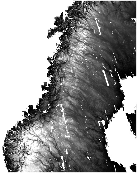
The xml above generates a shell script that you must run manually. The code snippet below shows the code for generating a single tile (h18v02 central Scandinavia) shown in the figure below.