Introduction
When you work with Karttur’s GeoImagine Framework you must have a predefined geographic region linking to an also predefined projection system. In the previous post you updated the Framework postgres database to include the projection system “sweref” (the Swedish national grid). The definition, however, only included the name and EPSG code of the projection. Plus a database schema with empty tables where all the spatial data belonging to this system will be registered. In this post you will run three different Framework processes for completing the definition of the projection system, add a default region and a user project based on the new projection system:
- DefineCustomSystem [for defining the boundary and tiling of the new projection system]
- DefaultRegionFromCoords [for defining a default region that exactly matches the system boundary]
- ManageDefRegProj [for defining a user project and tract that matches the default region and system boundary]
The three processes are accessible from the Framework module setup_processes.
Prerequisites
You must have updated the database to include the projection system as prescribed in the previous post.
Process chain
The Framework processes that are required for preparing the new projection system are compiled in the command file sweref_setup_20220122.txt:
\## Define the SWEREF tile/project systems
sweref_system-define_v090.json

\## Define SWEREF default region
sweref_defaultregion_v090.json

\## Define SWEREF user project
sweref_user+project_v090.json
DefineCustomSystem
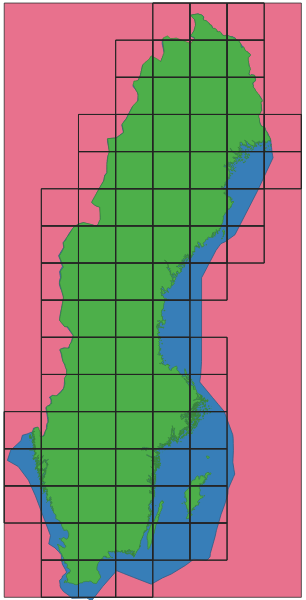
The Framework process DefineCustomSystem defines the boundary and tiling of a projection system. For the Swedish national projection grid, SWEREF99, I defined the boundary and tiling following the default map sheet system (see post on accessing open data from Lantmäteriet, the Swedish mapping, cadastral and land registration authority): sweref_system-define_v090.json.
DefaultRegionFromCoords
To access the complete region covered by the projection system (sweref) I added a default region, also called sweref, that exactly matches the boundaries of the projection system. The default region is defined using the same projection (EPSG) as the system: sweref_defaultregion_v090.json
When registered in the database the geographic corners in longitude and latitude are automatically calculated and added. You can inspect the new default region directly in the postgres database with the query:
SELECT * FROM system.regions WHERE regionid='sweref';
ManageDefRegProj
To access the new projection system and its default region a Framework user must create a project that includes a tract that is defined from the default region (sweref in this example). I defined the new project using the system default user, karttur, and then called the new project karttur-sweref. Then I also called the new tract karttur-sweref: sweref_user+project_v090.json.
If you want to check out that the project was added to the database, use the query:
SELECT * FROM userlocale.userprojects WHERE projid = 'karttur-sweref';
And to check out the tract:
SELECT * FROM regions.tracts WHERE tractid = 'karttur-sweref';
Get national boundary
In the example used in this post a national projection/grid system is defined (for Sweden). All nations, and their boundaries, are included in a default dataset in Karttur’s GeoImagine Framework. You can thus get the boundary for any country and for any projection by using the Framework process ReprojectDefaultRegionProjSys.
Next step
The new projection system (sweref) is now defined, but you must also update the Postgres database to allow the Framework processes to access the new projection system datasets, the topic of the next post.