
Outline
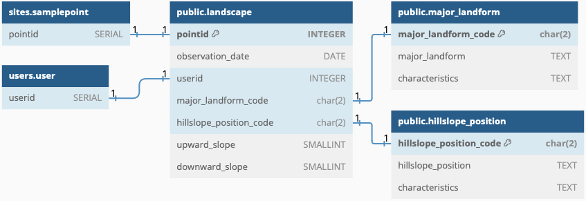
The landscape schema contains the tables that describe the more constant above ground characteristics around each sample point. The landscape description in the database should represent an area of approximately 25 m2 centred around the central pit of each sample point.
The tables major_landform and hillslope_position are catalogues of predefined different landscape elements and positions. Major landform and hillslope position can only be registered in the database by selecting one item from these predefined catalogues.
Idea and objective
Permanent landscape characteristics around each sample-points are regarded as static over the duration of the AI4SH project. The data in the landscape schema is thus not associated with any particular sampling event. One possibility is to identify landscape elements and postions from remote sensing and other spatial data and just let the user confirm, or manually alter, the proposed classification.
DBML
// Use DBML to define your database structure
// Docs: https://dbml.dbdiagram.io/docs
// Tool: https://dbdiagram.io/d

Project project_name {
  database_type: 'PostgreSQL'
  Note: 'AI4SH schema for landscape'
}

Table users.user {
  userid SERIAL
}

Table sites.samplepoint {
  pointid SERIAL
}

Table landscape { // constant
  pointid INTEGER [pk]
  observation_date DATE
  userid INTEGER
  major_landform_code char(2)
  hillslope_position_code char(2)
  upward_slope SMALLINT
  downward_slope SMALLINT
}

Table major_landform {  // constant
  major_landform_code char(2) [pk]
  major_landform TEXT
  characteristics TEXT
}
// major_landform alternatives: "level", "sloping", "steep", "composite"

Table hillslope_position {
  hillslope_position_code char(2) [pk]
  hillslope_position TEXT
  characteristics TEXT
}

// hillslope_position alternatives: "plain", "slope shoulder", "midslope", "footslope", "upland valley", "mesa", "peak/major ridge", "valley in plain", "canyon", "large valley", "local ridge in slope", "local ridge in plain"

Ref: "users"."user"."userid" - "public"."landscape"."userid"

Ref: "public"."landscape"."major_landform_code" - "public"."major_landform"."major_landform_code"

Ref: "public"."landscape"."hillslope_position_code" - "public"."hillslope_position"."hillslope_position_code"

Ref: "sites"."samplepoint"."pointid" - "public"."landscape"."pointid"
Figure